Page under construction, not yet complete. Last update Wednesday 13th May 2026 [reorder the sections into date order]
 . . .
. . . 
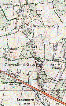
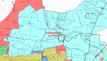
The location of Broxmore House and Park
Contents of this page
- Introduction
- The House
- The Stable Courtyard
- The Park
- The Bristow Family
- Sophia Durie, Miss Bristow and Mr Bull
- Broxmore House in the hands of the army in the second World War
- Breakup and sale of the estate 25th Nov. 1947
- The house and estate as recorded in the 1842 Tithe Award and 1841 census
- Demolition of the house
- The pig farm on the site after demolition
- The new houses on the site
- Hugh Quigley's description of the house and estate
- The last open arable fields in the parish in 1842 and the footpaths from Whiteparish that served them
See also (these links are currently for private viewing only, not yet available on the public internet)
- Broxmore House and Park a much more detailed account
- Broxmore Farm
- Broxmore Park Buildings includes the walled garden
- Home Lodge the lodge gate on Bunny Lane where the drive from East and West Lodge crosses
- Bristow family
Introduction
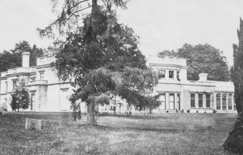
There are three buildings that have been referred to as Broxmore House: the farmhouse of Broxmore Farm, the house described on this page and a modern house that stands just to the east of the site of this original house. Broxmore Farm farmhouse, described on the Broxmore Farm page, was built soon after Melchet Forest was disafforested and enclosed in 1610, at about the same time as Ash Hill House. The Broxmore House of this page is situated close to the north end of Bunny Lane at the extreme east end of the parish. It was known both as Broxmore House and Broxmore Hall (the latter possibly only by Taylor?) and surrounded by parkland that is present to this day and a feature of the Whiteparish landscape: it is pictured below. A new estate of large houses was constructed around the site of Broxmore House from the 1960s and one of these, a little to the east of the original building, is also called Broxmore House.
Photograph of Broxmore House
also at lostheritage, Cobern Edmunds Blogspot and various other websites
Broxmore Park is the most easterly parkland in the parish and together it, Popplehill Park, Morrisholt Park and the parkland associated with Cowesfield House form a very distinctive parkland landscape, visible on the left from the A27 when leaving the village towards Romsey. Between them they stretch from Forty Acre Lane (Miles Lane) to the county boundary.
Broxmore House was a very grand house used for entertaining. It was built by Robert Bristow in 1812 to replace the Alderstone manor house that had stood next to the church since 1562. The old house was demolished and used in the foundations of the replacement manor house at Broxmore and quickly lost from memory. A chance breakthrough into its well occurred on the 21st April 2016 when a trench was being dug to connect the new Memorial Hall to mains electricity, water and sewage. It was quickly capped and is now buried beneath the car park, but not before Peter Claydon had taken some carefully lined up photographs to show exactly where it was.
To introduce Broxmore House we can do little better than to quote from Matcham's book of 1844, remembering that it the owner and Lord of the Manor at the time, Robert Bristow, who had the house built. Matcham's language in describing the property comes from another age: a turn of phrase in which he as a member of the landed gentry diplomatically describes the property of a neighbour who has kindly helped him with his research into the history of Whiteparish and allowed him access to the family archive. The book includes the description below and also Robert Bristow's family tree. So, in Matcham's words:
When the ancient manor-house had been taken down, in the year 1812, a new residence was commenced by the present lord of the manor of Alderston, at Broxmore, within this tything. The lands so called, with Cotmore and Doxmore, formed a portion of the original estate conveyed by Ingelram Berenger in 1330 to the family of Sparsholt; and, being granted at the reformation to William St. Barbe, were included in the original purchase of Mr. Bristow's ancestor. Additions, however, have been since bought, by which this part of the property has been considerably enlarged.
Broxmore was originally intended by the proprietor as an occasional residence for the enjoyment of field sports rather than as a mansion, but, by several additions, it is now much enlarged, and has assumed the character of a considerable Italian villa. The Architect, Mr. C.H. Tatham, has, I believe, superintended the whole, and, although from the different dates of the building no uniformity of design has been attempted, yet the general effect of the facade is not unpleasing. The interior presents a range of apartments in which comfort is combined with space, elegance and appropriate decoration.
In the book Matcham then goes on to list the paintings hung in the House. This was entertaining on a very grand scale.
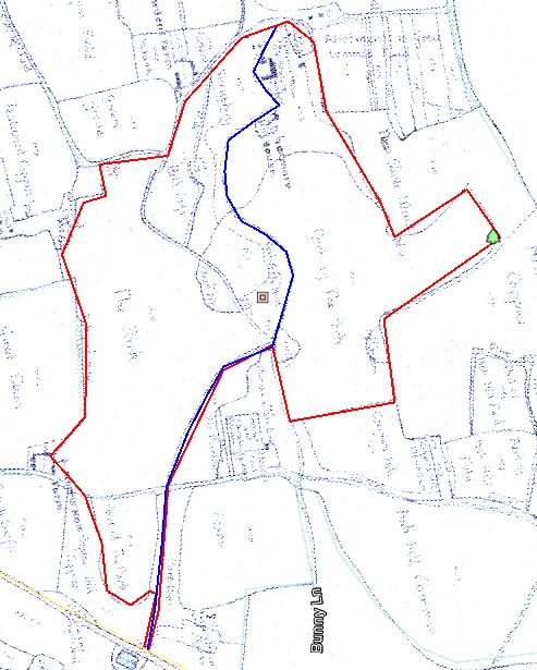
The outline of the park can be seen below superimposed on a Google Earth background, with the approximate positions of buildings marked in orange. The blue line shows the course of the drive, leaving the A27 at the bottom of the page and crossing Bunny Lane before reaching the house.
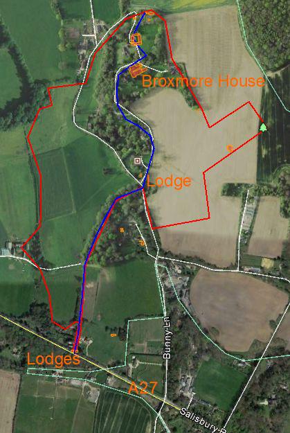
The extent of Broxmore Park in red, drive from the turnpike road (A27) in blue, key buildings highlighted in red
Base map copyright Google Earth
The House
Broxmore House was built in 1812 in the area of the last of the Alderstone open fields, close to Cowesfield Louveras. It was described by both Matcham and Taylor and had a grand park around it on land that had been part of Alderstone Manor since at least 1166, and was there until it was demolished in 1949. Several photographs of the low two storied building with stuccoed Regency style walls have survived, even though the house hasn't. A park was laid out in front and to the south of the House, with 'temples', etc., and with Regency style lodges at the entrance to the main drive from the A27. The West Lodge is still there and has been extended and improved as Westlyn, but the east one has gone. A new "East Lodge" was built further from the road in 2002-2005 and the extended house on the site of the original lodge demolished between 2008 and 2014. It is possible that the half timbered garage just north of the position of the original east lodge and visible through the trees from the road imitated the style of the original lodge. A further lodge was situated where the drive crosses Bunny Lane. These and the other park buildings are described here. The architect was Charles Heathcote Tatham (1722-1842) and drawings still exist of a couple of the associated buildings - a 'cottage villa' dated 1807 and of an ice house dated 1811. This ice house was broken into when the present Broxmore House was being constructed in [date - around 2020]
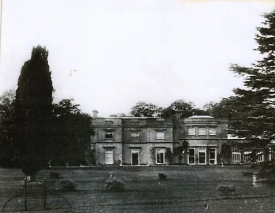
A photograph of Broxmore House from the 1953 WI scrapbook
The Stable Courtyard
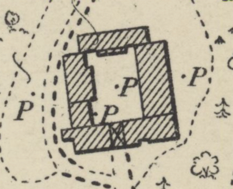
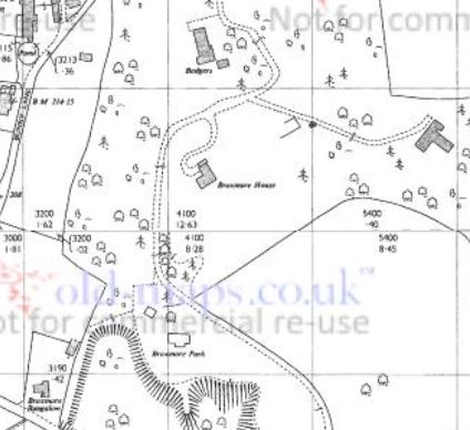
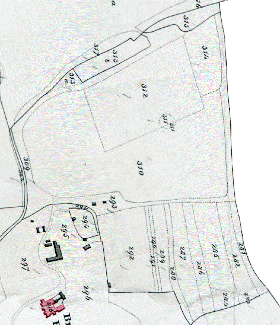
The stables at Broxmore House stood about 80 metres (90 yards) north of the house. In 1842 they were in the form of an L shaped block, extended to form a closed courtyard by 1876. It was recorded in 1941 that 133 Company of the army was based here during World War 2, "comprised of four platoons, A, B, C and workshops platoons plus HQ staff. The officers and HQ staff were based and billeted in the big house. The men were billeted in the stable blocks on three sides of a courtyard." bbc history. As shown on the map below the stables appear to have had an extensive set of pumps to supply water in the area, possibly supplied from underground water tanks. I know of two houses in Whiteparish that had underground rainwater tanks: the Vicarage opposite the church and Abbotstone House. In both cases I understand that water was manually pumped daily into tanks in the loft to supply taps. I assume that there must also have been a well, although haven't seen this on any of the maps I've studied.
 .
.
 .
.
.gif) .
.
The stable courtyard in 1901, relationship to the house and an extract from the conventional signs for the 1923 1:2500 map showing that P represents a pump
For the full set of signs see here
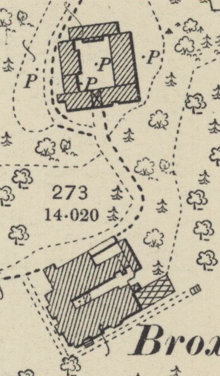
The four map extracts below show the development of the stables from 1842 through 1876 and 1900 to 2026, where a house named Badgers sits squarely across part of the stable block site. Note the extensive water distribution via pumps on the 1900 map. These maps are georeferenced by the source shown, although the survey accuracy of the 1842 Tithe Award map results in the stables being shown in a slightly different position. I've not established (yet) whether the 1842 buildings survived as part of the 1876 or whether the buildings were all renewed. (Note that dates given in this website use map survey or revision dates when available, rather than publication dates.)
.gif) .
.
.gif) .
.
.gif) .
.
.gif)
Comparison 1842, 1876, 1900 and 2026, the latter showing the house named 'Badgers'
These views are georeferenced using Know Your Place - the 1842 map is slightly displaced from the others by surveying inaccuracy
[Add a traced overlay of Badgers on the 1900 survey]
The Park
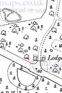
Broxmore Park, laid out by Robert Bristow (4) in 1812, extended over a large part of the eastern section of Alderstone manor that lies to the north of the A27. It had an ice house, temples, stables, a summerhouse, houses for staff, east and west lodges on the A27 at the entrance to the drive, and a third lodge, Home Lodge, where the drive crosses Bunny Lane. Some of these buildings are still there, while others have been extended or rebuilt. Almost all these buildings, apart from some of the staff houses, were used by the army during the second World War.
On the map below the drive is marked in blue and the boundary of the park in red. The A27 runs across the bottom left corner of the map and Bunny Lane runs northward from the A27, crossing the drive at the centre of the map and running along the northwest boundary at top left.
 .
.

Approximate boundaries on the 1842 Tithe Map, the map and boundaries superimposed on Google Earth terrain view on the right
There are slight surveying inaccuracies from 1842 that mean alignment isn't perfect
The Bristow family
Bristow family (this page not yet available on the public version of this website).
Broxmore House was built and the old Alderstone manor house next to the church demolished in 1812 by Robert Bristow. Earlier owners of Alderstone Manor from William St Barbe to Robert Bristow are listed under Occupiers and Owners in Alderstone Manor House.
Members of the Bristow family were lords of the manor of Alderstone from the purchase of the manor by Robert Bristow (2) in 1725 until its breakup for sale as individual farms and houses by Mr Bristow Bull in 1947. All Saints Church was initially the manor's place of worship within a tithing that contained only Alderstone manor, and as such the lords of the manor owned the Advowson, that is the right to present new rectors and vicars.
The list below includes the parents, grandparents and great grandparents of the Robert Bristow (2) who bought Alderstone Manor in 1725. The generation numbers are my way of keeping track of individuals when successive generations have the same name. For a complete pedigree of the family see Matcham page 11.
- John and Mary Bristow, parents of Robert Bristow (0)
- Robert Bristow (0) 1629-1707 married 1662 Averilla Curtis of Ware, Gloucester, Virginia in Virginia
- Robert Bristow (1) 1662-1706 (MP) married 1684 Katherine Woolley (1667-1751)
- Robert Bristow (2) first born, died an infant
- Robert Bristow (2) 1687-3 Nov 1737 second born (MP), 1709 married Sarah Warde -1741, bought Alderstone Manor in 1725
- Robert Bristow (3) 1712- 9th December 1776 , 1746 married 1. Susannah Phillipson, 2. Mary Harding 1748-1812
- Robert Bristow (4) 1773-1853, 1831 married Miss Sophia Twine of Ramsbury, demolished the manor house by the church in 1812 and had Broxmore House and Park built [wikitree: Robert married Mary Twine (aged 19) 19 November 1828, Mary died 1831, Robert then married Sophia Twine (aged 19) 19 Sep 1831. She outlived him and remarried...
- Sophia Twine/Bristow (aged 46) then married Charles Durie 13 April 1858 [wikitree]
- Robert Bristow (5) 1844-1883, born 1844 or 1847, died 1873 or 1883 [churchyard plot 234], 1867 married Louisa Weston (who died 16th March 1887) [Sara A plot 234]. His mother Sophia still held the estate at his death so he didn't inherit
- 1870 14th October Robert Bristow (6) born, died 6th June 1871, buried 10th June 1871
- Sophia Twine/Bristow/Durie inherited the manor and advowson and died in 1896
- [being confirmed] Mrs Bull (presumably nee Bristow) and Miss E.S. Bristow inherited the manor and advowson in 1896 on the death of Sophia their mother [to confirm]
- 1939 Miss Evelyn Sophia Bristow moved out of Broxmore House when it was requisitioned by the army [Wikitree has died about 1936]
- 1947 Mr Bristow Bull divided up and sold the manor (see below)
Sophia Durie, Miss Bristow and Mr Bull
As seen in the list above, Robert Bristow (4) married Miss Sophia Twine of Ramsbury, and it was he who demolished the manor house by the church in 1812 and built Broxmore House and Park. Sophia remarried after Robert's death, and as Mrs Durie was much involved with the church and village.
The church graveyard was due to be extended by one rood (a quarter of an acre) and consecreted at the service reopening the church on 24th April 1870 after the Butterfield restoration was completed, but the donor of the land, Mrs Durie, of Broxmore House, was severely ill and not at home. This delayed the churchyard extension for a few months, and a faculty was later applied for, stating: "Churchyard insufficient for 'purposes of sepulture'. A plot of land of one rood or thereabouts, on south side and immediately adjoining churchyard, by deed of 21 June 1870 has been freely conveyed by Charles Durie of Broxmore Park, and Sophia his wife" [ All Saints Church]. This land had originally been part of the garden of the manor house alongside the church on Common Road.
Thirty years later the churchyard was again full, and again it was the family who provided further land, another slice of the land on which the manor house next to the church had stood and its garden. The vicar reported to the vestry meeting held on 3 April 1899 that an extension to the churchyard was urgently required, there being space for less than 20 further burials [vestry book WSA, 830/16]. Further vestry minutes refer to this and a portion of land adjoining the churchyard was purchased from Miss Bristow and Mr Bull and consecrated in 1902 [WSA, 830/16, mins. 17 Oct. 1900, 8 Apr. 1901; Salisbury Times, 17 Jan. 1902, 8]. By chance the 1876 map postdates the first extension and the 1900 map predates the second, showing the same churchyard boundary. Further extensions of this kind were not possible after the breakup and sale of the manor's lands, and the remainder of the old manor house plot is now occupied by the Memorial Ground/Surgery car park and the Surgery itself, as well as by the two new houses behind and above the surgery: Steeple Barn and Church Barn.
As seen in the list above, two Bristow sisters, Mrs Bull and Miss E.S. Bristow inherited the manor when Sophia their mother died in 1896, and Miss E.S. Bristow moved out of Broxmore House when it was requisitioned by the army in 1939. The Mr Bristow Bull who divided up and sold the manor in 1947 was presumably either Mrs Bull's husband or her son [working on clarifying this].
Broxmore House in the hands of the army in the second World War
Broxmore House and most of its buildings were requisitioned by the army in 1939 and Miss E.S. Bristow moved out, although some of the residents of other buildings remained, notably in the two lodges on the A27. It appears that the house may have been used for more than one purpose at different times, as the account below from 1941 is about 133 Company, while Hugh Quigley (see below) mentions its use to house Austrian prisoners.
'The Lighter Side of War' by Don Alexander has a chapter recording some of the goings on at Broxmore House during the war. This is well worth a read and includes a list of names of some of the people posted there. It can be found in the BBC Archive. A brief extract provides a helpful introduction:
"CHAPTER 7a: `A' Platoon, 133 Coy RASC Broxmore House Whiteparish, Salisbury, Wilts May - Sept 1941
Broxmore was another mini stately home (now demolished) commandeered by the Army. 133 Company here was comprised of four platoons, A, B, C and workshops platoons plus HQ staff.
The officers and HQ staff were based and billeted in the big house. The men were billeted in the stable blocks on three sides of a courtyard. The surrounding acres with sundry sheds previously housing livestock were now workshops and home to many of the company's lorries. And there were a lot of these. Eighteen lorries per platoon - either Morris C 38's or Bedford three-tonners. There were two men to a lorry. Platoons A, B and C were each divided into three sections, each with six lorries and twelve men, drivers and driver-mechs. Driver-mechs were capable of minor repairs, adjusting brakes, changing oil, adjusting points etc."
Breakup and sale of the estate 25th Nov. 1947
See National Archive for details of the sale document. The document itself is held in the Historic England Archive.
- Broxmore House, Romsey Road, Whiteparish (demolished 2 years later)
- Ash Hill House, Romsey Road, Whiteparish
- Morrisholt Farm, Whiteparish
- Ash Hill Cottage, Whiteparish
- Broxmore Farm, Romsey Road, Whiteparish
- West Entrance Lodge, Romsey Road, Whiteparish
- There were two lodges by the A27, now Westlyn and East Lodge
- The entrance drive from them crossed Bunny Lane to get to the house
The house and estate as recorded in the 1842 Tithe Award and 1841 census
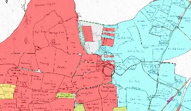
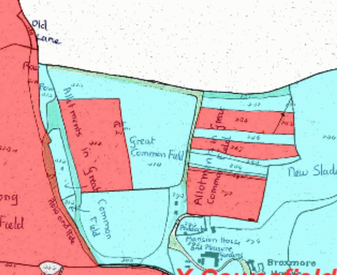
By 1842 Broxmore House and Park were well established, having been built in 1812 by Robert Bristow (4) (1773-1853). His own land was divided between park and farmland and he rented most of Cowesfield Louveras from Lady Fremantle as additional farmland, as shown below.
 .
.
LEFT: Land owned by Robert Bristow (blue) and Lady Fremantle (red) in 1842
RIGHT: Land under the control of Robert Bristow in 1842 as owner and tenant (blue) (east at top of these maps)
As observed frequently on this website, the serendipitous juxtapostion of the 1841 census, 1842 Tithe Allocation Award and Matcham's 1844 book on the Hundred of Frustfield together give us a rounded view of the population and their occupations and a detailed account of how the land was owned and used.
Demolition of the house
The pig farm on the site after demolition
The new houses on the site
The pig farm was sold in the early 1960s in six several plots on which houses were developed separately. At least two of the houses (Broxmore House and Badgers) have been replaced, built anew or extended in the last 20 years [2026 - for a detailed account and references see the private page Broxmore House and Park.]
[Further text ready to be copied into this section]
 .
.
.jpg)
Broxmore House and Rowden's Farm area in 1967
The right hand map has the 1901 buildings overlaid to show the original House and Stables in context
.jpg) .
.
.jpg)
The central and southern sections of the park showing 1901 buildings in red over the 1967 map
The building closest to the top left of the central (left hand) map is a lodge where the drive crosses Bunny Lane
The walled garden is bottom left of the same map, now laid out as the ornamental garden of the house named Broxmore Gardens
 .
.
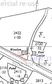
The Broxmore Park Lodges by the A27 in 1909 and 1967
There was another lodge where the drive crosses Bunny Lane
Hugh Quigley's description of the house and estate
A particularly evocative image of Broxmore House was remembered by Hugh Quigley in his book "Melchet". He wrote: The avenue with its prolongation through Plaitford Wood, almost a mile long, was composed of the remains of Broxmore House, demolished in 1950 [1949 according to the references elsewhere on this web page]. Before the war I knew it as an architecturally beautiful residence, late Georgian in style with magnificent lounge and living room panelled in old black oak with ceilings decorated in carved and sculptured wood. It gave on a close of cypress and cedar rising to a hill of magnificent oaks, straight and clean in butt with pale grey bark, a sure indication of quality and beyond them the deer park with a choice herd of white deer. [I think he mentions here the old lady living there dying] ...the war intervened, the old house was used for Austrian prisoners,... it was neglected and abandoned to its fate,... [Melchet, Hugh Quigley, Holmes and Sons, 1970, p95 under the date 18.12.1969]
Hugh Quigley held and cultivated a piece of land on the Melchet estate. I've not yet been able to establish where the "avenue" referred to above is located.
The last open arable fields in the parish in 1842 and the footpaths from Whiteparish that served them
Alderstone and Cowesfield Louveras had earlier been owned by the same person for a time [add details] and when the properties were divided and sold separately the last remaining arable open fields of the two manors in this area were divided between the two manors in alternating blocks as shown in the map below, the original division having presumably been lost.
 .
.  .
. 
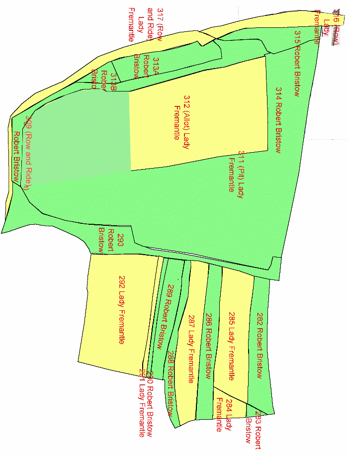
Division of the last remaining open field arable strips between Alderstone and Cowesfield Louveras in 1842
Left hand map... Yellow: Cowesfield Louveras owned by Lady Fremantle; Green: Alderstone owned by Robert Bristow
Right hand map... Red: Cowesfield Louveras owned by Lady Fremantle; Blue: Alderstone owned by Robert Bristow
[Redraw the left map]
This subdivision of the arable open fields between the two manors makes more sense on the right hand map above, which shows a wider view of the boundary between the manors. These fields clearly lay within the bounds of Alderstone, but with some owned by Cowesfield Louveras. It seems probable that these were originally Alderstone fields but that during the period when the two manors were owned together tenants were allocated strips here and the Cowesfield Louveras fields reused in other ways. At the redivision of the manors, a practical approach would have been to divide these remaining fields between the two manors rather than creating new ones in Cowesfield Louveras. In mediaeval times the larger part of the parish in almost all the manors would have been covered by open arable fields, this being just a tiny remnant of that earlier form of land usage.
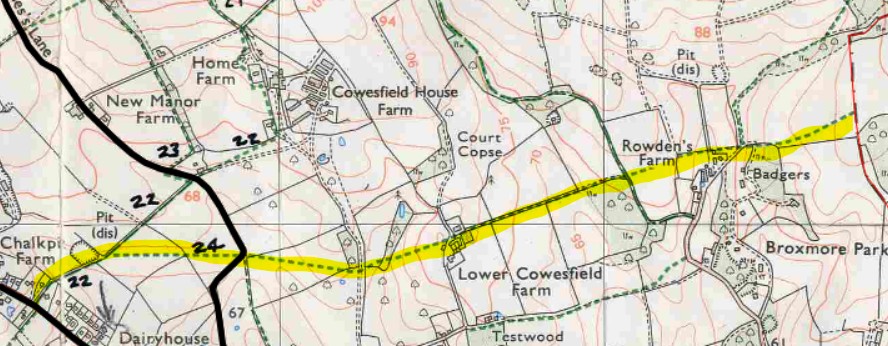
An interesting leftover feature of these last open arable fields is the footpath that runs to them from Romsey Road, passing diagonally across the field behind Meadow Court, providing direct access from the other half of Alderstone manor around the church, where there had presumably been people still with rights to one or some allocated strips each year after closer ones had been enclosed. The footpath passes Lower Cowesfield Farm and Rowden's Farm, reaches and crosses the area that had been covered by these open fields then stops at the county boundary, and can still be followed today. Its end on the county boundary was in the middle of a wheat field when I visited last in recent years [written 2026]. A second footpath branches from it and passes round the north edge of these fields, following the boundary between the two manors, turning then towards the northeast across Cowesfield Louveras to cross Gatmore Copse and take you on into Hampshire.
. 
A wider view of the Alderstone-Cowesfield Louveras boundary in 1842 and the modern footpaths that originally served the open fields
Red: Cowesfield Louveras owned by Lady Fremantle; Blue: Alderstone owned by Robert Bristow
The route of the footpath from Romsey Road to the last Alderstone arable open fields